Requests for Instruction
Interested in having a data-related instruction session for your class or group? Instruction sessions are available upon request by UNC faculty and staff. We also provide customized instruction sessions as needed. For instruction opportunities available to those not affiliated with UNC, please see our events calendar.
To request an instruction session, please browse our offerings below, then click “Request This Instruction Session.”
Browse Instruction Sessions by Topic
Finding and Understanding Data
How to Find Data Sources (General; appropriate for first year students)
The class begins with a discussion of the elements of a research question; general tips on the types of places likely to have data; and a range of things to consider when hunting data. After teaching students how to identify the most important elements of a data set and where to look for them, the instructor provides a walk-through, comparing two online statistical databases (such as the Statistical Abstract of the United States and Statista) to point out features and get students thinking about the pros and cons of using different sources. This session can easily be flipped so that students go through a slide presentation before class and/or do the exercises in advance in order to spend class time on discussion and students’ questions.
How to Find Data Sources for a given discipline or topic area (specific to a given course and assignment)
Customized to a specific course or assignment, this option is useful to give students a range of suitable places to start to find data. The class starts with the same discussion as above, then turns to sources specific to the particular course or assignment. This can easily be flipped so that students go through a slide presentation before class and spend class time looking for data for their projects and asking questions.
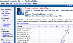
Census/American Community Survey (ACS) data methodology
This workshop covers the basics of Census and ACS methodologies, geographies and variables, and the differences between the two surveys. The material is customizable to include some or all of these topics and hands-on exercises.
Acquiring Census data through the easy-to-use Social Explorer database
Introduction to an easy to use database for current and historical Census data. Could be used for written assignments to encourage students to add statistics to support their arguments, or may be used for extensive data-gathering for research. Social Explorer includes map-making capabilities, and comparison features that can be used in class (or conference) poster sessions. Appropriate for all levels from first-year students to faculty.
GIS and Mapping
ArcGIS Pro for Beginners
ArcGIS Pro is one of the most widely used GIS software platforms, with a range of applications that include business analytics, natural and health sciences, transportation, and more. Its suite of tools offers capabilities for analytics and data science, automation, data management and editing, image analysis, and artificial intelligence. This hands-on course for beginners will provide an overview of ArcGIS Pro, including its layout and capabilities. Topics covered will include importing geographic data, styling and symbolizing data, querying and selecting data, and making basic maps.
StoryMaps and Web Mapping in ArcGIS Online
Creating maps for the web is an excellent way to visualize information and communicate research. ArcGIS Online is a popular web mapping platform used for online data analysis and visualization. StoryMaps allow users to make informative, map-based webpages without any coding! Attend this online workshop to learn how fun it can be to make sharable, interactive maps. This hands-on, guided workshop will begin with a short overview of the capabilities of ArcGIS Online. The rest of the workshop will focus on how to create StoryMaps. By the end of the workshop, attendees will understand the basic functions of ArcGIS Online – such as adding and storing data and sharing web maps – and will be able to create their own beautiful, interactive StoryMaps.
Data Visualization
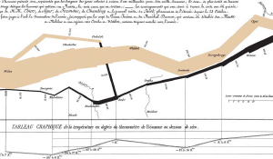
Making an Impact With Data Visualization
Collecting data is now easier than it has ever been. But, as data becomes more prolific, datasets become larger and more complex. How do we find meaningful patterns in our data? How can we communicate those patterns to others? Data visualization allows us to make sense of today’s ever evolving information landscape. This lecture introduces the history and basic principles of data visualization. Learn about best practices and resources for making an impact with your data through compelling charts, graphs, and maps.
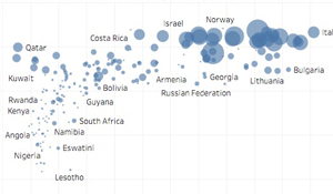
Tableau I
Tableau is a user-friendly software application for creating visualizations and interactive dashboards.
Examples can be found here.
Tableau’s drag-and-drop interface provides tools to build a variety of visualizations with no coding required, and visualizations can be published online and embedded in websites. In this workshop, participants will create basic visualizations and an interactive dashboard in Tableau.
Tableau II
This workshop continues to explore methods used in creating visualizations and dashboards as introduced in Tableau I.
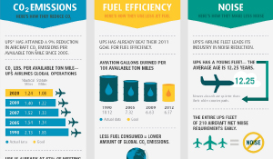
Working With Infographics
Data visualization is an important tool for communicating complex information, but academic presentations of data can be difficult for some audiences. Infographics are a style of data visualization that is more accessible to a non-academic audience. This lecture provides practical tips for creating infographics and invites critical discussion of examples.
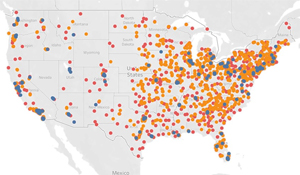
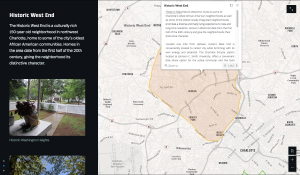
Let’s Make a Story Map with ArcGIS Online
ArcGIS Online is a popular web mapping platform. The ArcGIS Story Maps feature allows users to make informative, map-based web pages without any coding.
Examples can be found here.
This hands-on workshop introduces the ArcGIS Story Maps tool. Participants are guided step-by-step in creating a small Story Map. If your course requires students to complete a Story Map project, this workshop is an ideal way to learn and practice using the tool.
Data Visualization in Libraries (for library classes)
Why are Data Visualization services offered in academic libraries? What does a Data Visualization Librarian actually do? This lecture explores the role of data visualization in research, introduces and explains various types of visualizations, and provides examples of data visualization questions I am asked by researchers on a daily basis. It includes ample time for questions and discussion.
Data Visualization in Libraries (for data visualization classes)
This purpose of this lecture is to provide students with examples of data visualizations that are created in a professional setting. I will talk about various projects in which I have collaborated with researchers across domains, and demonstrate interactive dashboards I have created for library administration.
Data Visualization Tools & Resources
This short lecture discusses various data visualization tools, ways in which they are used for research, and how they can be accessed. The methods and resources featured in this lecture can also be found on the
Data Visualization page.
Working with Data
Data Management
Customized to the audience, this material can be adjusted to answer particular questions from participants or address the needs of a particular discipline/department. Can include: an introduction to what data management is; elements of a data management plan (DMP); tools for writing DMPs; funding agency data management guidelines; how to find an appropriate data repository and/or metadata standard; and/or data management strategies.
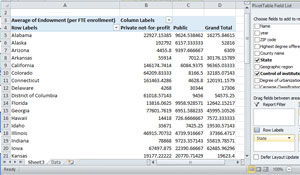
Excel Basics
Want to work with data without the hassle of programming? Microsoft Excel is a great choice for your data processing needs. By using spreadsheets, formulas, and an array of specialized features, users can more easily organize, edit, and analyze their data. This workshop will cover some useful tools for effectively navigating, manipulating and summarizing data in Excel.
Humanities and Archives
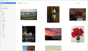
Manage Research Images with Tropy
Conducting research with lots of images or pdf files and not sure how to organize them? This workshop will walk participants through using a tool called Tropy to manage many types of research images. Participants will learn how to use the software, as well as some tips on frequently used features like subject tagging and merging separate images into one object (helpful when working with multiple pages of a letter, for example). No prior knowledge is needed.
Making the Most of Your Time in an Archive: Archival Research Management, or Tips from Practitioners
Archival research can be exciting but also somewhat complex for a new researcher. This workshop draws on the expertise of long-time researchers to offer a roadmap for neophytes. Learn strategies for all stages of research: before you go; while you’re there; after the archive closes; and once you return home.
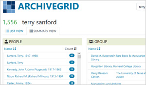
Identify the Best Sites for Your Research with ArchiveGrid
Need help figuring out which archives hold the research material you need? This workshop will introduce researchers to ArchiveGrid, a database cataloging archive collections around the world. In addition, participants will learn other tips for formulating research questions and plan their research.
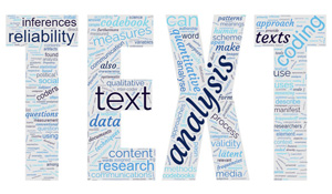
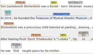
A Gentle Introduction to Text Analysis I
A “gentle” introduction to text analysis is one that allows participants to examine real-world examples and engage in hands-on activities without using a programming language or running any code. It is ideal for students and researchers in non-technical fields, faculty who would like to incorporate text analysis in their curriculum, or as a precursor to programming with text analysis tools.
A Gentle Introduction to Text Analysis II
This workshop continues to explore text analysis methods as introduced in A Gentle Introduction to Text Analysis I. We will conclude with a discussion on ethical problems in text analysis.