
Compasses, Cartouches, and Creatures: Exploring the Art of North Carolina Maps
Opens July 27, 2023
9:00-5:00, Monday-Friday, except holidays.
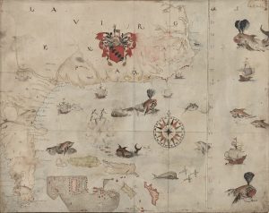
As a member of the first expedition to Virginia in 1585, the artist and explorer John White created a detailed rendering of the east coast of North America from Virginia to Florida. White’s work is considered the first map of the region drawn from direct observation. But it is also noted for its dramatic pictorial record of the voyage, with depictions of ships, flying fish, and formidable sea monsters.
Such artistic embellishments as animals, colorful compasses, and ornate title cartouches were common on printed maps during Europe’s Age of Exploration (1400s-1600s). And they helped sell maps to collectors, who were increasing in number. By the 1700s, however, mapmakers moved away from including such special features. Advances in technology and new mapping techniques turned cartography from art to science.
Still, decorative maps remained popular with consumers. For example, commemorative military maps used pictorial elements such as color and symbols to document terrain and troop movements of important battles. Birds-eye view maps of the late 1800s provided a detailed overview of an area, with depictions of buildings, moving trains, and factories with smoke rising from their chimneys. In the 20th century artists and illustrators used vibrant colors and humor to create maps for education and advertising.
This exhibition of reproductions explores a selection of historical North Carolina maps and the ways that mapmakers used artistic embellishments to educate, entertain, and entice. Explore this exhibition.
For hours, directions, and parking, see Wilson Library’s visit us page.
For information on previous exhibitions, see our past exhibitions page.

